Spain
Spain: It turns cooler, windier and wetter in places
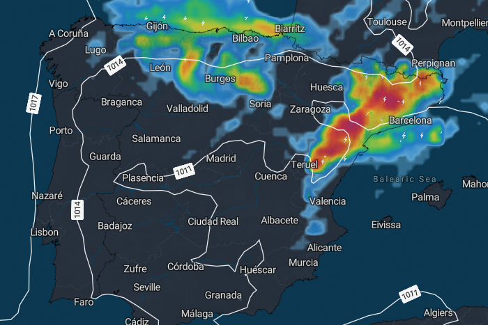
ICON-EU forecast run 18/08/26 ooZ for Saturday at 5:00 PM
On Wednesday, the heat will reach another peak in eastern Spain. Temperatures could locally climb to 40–42°C. After that, the weather pattern changes significantly: cooler air will spread across the Iberian Peninsula from the north and northwest, winds will strengthen, and the risk of heavy showers and thunderstorms will increase, especially in northern and northeastern Spain. By Saturday, temperatures will have fallen sharply in many areas.
The latest calculations from the ICON-EU model run of 18 August, 00 UTC, indicate a particularly noticeable change in Spain’s weather over the coming days. While Wednesday will bring another spell of extreme heat, especially in the east, a significant cooling trend will then spread southwards from northern Spain.Wednesday: Up to 42°C in eastern Spain
Wednesday, 19 August, will be exceptionally hot once again, particularly across eastern and northeastern parts of the Iberian Peninsula. The highest temperature is currently forecast around Valencia, with approximately 42°C. Zaragoza and Lleida could both reach around 41°C, while Murcia is expected to see about 39°C.
Away from these extreme heat hotspots, temperatures will also remain very high. Girona and Tortosa could reach around 36°C, Teruel approximately 35°C, Madrid 33°C and Toledo around 35°C.
Conditions will already be very different in northern and northwestern Spain. Along the Atlantic coast, highs are expected to reach only around 23°C in A Coruña, 24°C in Gijón and 26°C in Bilbao.
This means that temperature differences of almost 20 degrees could occur across Spain on Wednesday.
Winds will also become noticeable. Gusts of around 40–60 km/h are possible across many inland and eastern areas. The model indicates gusts of approximately 58 km/h around Albacete, 57 km/h around Burgos and Soria, and about 54 km/h in the Valencia area.
Thursday: The extreme heat is pushed back
On Thursday, 20 August, the temperature pattern changes considerably.
Zaragoza drops from around 41°C to 34°C, while Valencia falls from 42°C to approximately 35°C. A particularly noticeable cooling is expected across the northern interior, with León reaching only around 24°C, Burgos 25°C and Soria approximately 27°C.
It will be especially fresh along the northern coast. A Coruña and Gijón are expected to reach only around 21°C, with Bilbao at approximately 22°C.
Southern Spain, however, remains summery to hot. Sevilla and Cádiz are expected to reach around 30°C and 24°C respectively, Córdoba approximately 31°C and Málaga around 31°C. Murcia could still reach approximately 34°C. Rain and thunderstorms spread
As the cooler air arrives, the weather will also become increasingly unsettled. On Thursday, the main focus for rainfall is initially expected to be across northern Spain and parts of the northern interior.
The model calculates around 15 mm of rain near León, approximately 13 mm around Bilbao and around 8 mm near Soria. Showers and local thunderstorms are also possible between Burgos, the Pyrenees and the Ebro Valley.
Farther south, many areas should remain dry or receive very little rainfall.
Strong winds will be another feature of the changing weather. The Mediterranean coast is particularly noteworthy: around Almería, gusts could reach approximately 74 km/h. Gusts above 60 km/h are also possible in the Pyrenees, while Girona could see almost 60 km/h. Strong winds are also possible across Mallorca, the Ebro Valley and parts of the southeastern coast.
Friday: Much more comfortable, but increasingly unsettled in the northeast
The cooling trend continues on Friday, 21 August.
Along Spain’s northern coast, maximum temperatures will often reach only 19–21°C. Madrid is forecast to reach around 29°C, Zaragoza approximately 30°C, Barcelona around 27°C and Girona also approximately 27°C.
Southern Spain remains considerably warmer. Sevilla and Córdoba are both expected to reach around 32°C, with Málaga also close to 32°C. Murcia remains one of the hottest locations at approximately 35°C.
At the same time, the main area of rain and thunderstorms shifts increasingly towards northeastern Spain and the eastern Mediterranean coast.
According to the current ICON-EU calculations, around 12 mm could fall in Barcelona, approximately 8 mm in Girona, 7 mm around Bilbao and 6–7 mm around Soria and parts of the Pyrenees. With thunderstorms, however, rainfall totals can vary significantly over very short distances.
Much of central and southern Spain is expected to remain largely dry.
Saturday: Major cooling across northern and central Spain
By Saturday, 22 August, the scale of the weather change becomes particularly impressive.
Madrid is forecast to reach only around 26°C. Zaragoza falls to approximately 25°C, Lleida to around 24°C, while Soria could see a maximum of just 19°C. Burgos and León are also expected to remain around 19°C.
For comparison, only three days earlier, temperatures of around 41°C are forecast in Zaragoza and Lleida.
Conditions remain warmer along the Mediterranean coast. Barcelona could reach around 28°C, Valencia approximately 30°C and Murcia around 35°C. Across the southern interior, maximum temperatures will generally range between 27°C and 32°C.
Particularly heavy rainfall possible in the northeast
Saturday’s development is especially interesting across northeastern Spain.
The ICON-EU model indicates the potential for locally substantial rainfall. Around Lleida, approximately 46 mm could fall within 24 hours, with around 24 mm near Tortosa and approximately 11 mm around Baqueira in the Pyrenees. Further rain is also forecast between Girona, Barcelona, Aragón and the western Pyrenees.
These rainfall totals should not be interpreted as precise point forecasts, particularly where thunderstorms are involved. The important signal from the model is that the risk of heavy and locally intense showers and thunderstorms increases significantly across northeastern Spain.
Southern and southwestern Spain, meanwhile, should remain predominantly dry.
Wind will also be an important factor
The change in weather will not only bring lower temperatures and rainfall. Winds will also become quite strong in some regions.
Strong gusts are repeatedly indicated along the southeastern Mediterranean coast. Around Almería, gusts could reach approximately 74 km/h on Thursday, with another peak of around 72 km/h possible on Saturday. Strong winds are also possible in the Pyrenees, the Ebro Valley and at times across the Balearic Islands.
For holidaymakers along the coast, it will therefore be worth keeping an eye not only on temperatures but also on local forecasts for wind, waves and thunderstorms.
From extreme summer heat to much more comfortable conditions within days
Overall, Spain is facing a remarkable change in weather. On Wednesday, eastern Spain will experience another day of extreme heat, with maximum temperatures between 40°C and 42°C. After that, the very hot air will gradually be pushed towards the southeast.
On Thursday, the cooler air reaches northern and central Spain while the first more significant areas of rain and thunderstorms develop. Friday and Saturday bring a further drop in temperatures across many regions, while the main focus for rainfall increasingly shifts towards the northeast.
The temperature drop will be particularly dramatic around the Ebro Valley. Locations experiencing more than 40°C on Wednesday could see maximum temperatures of only around 24–25°C by Saturday.
For large parts of Spain, this will bring welcome relief from the extreme August heat. However, the change in weather should not be underestimated in northern and northeastern Spain, where strong thunderstorms, locally heavy rainfall and powerful wind gusts could make conditions temporarily quite unsettled.
You can follow the latest developments and regional forecasts as always on meteo365.es.