Spain stays unsettled: heavy rain in Catalonia on Sunday
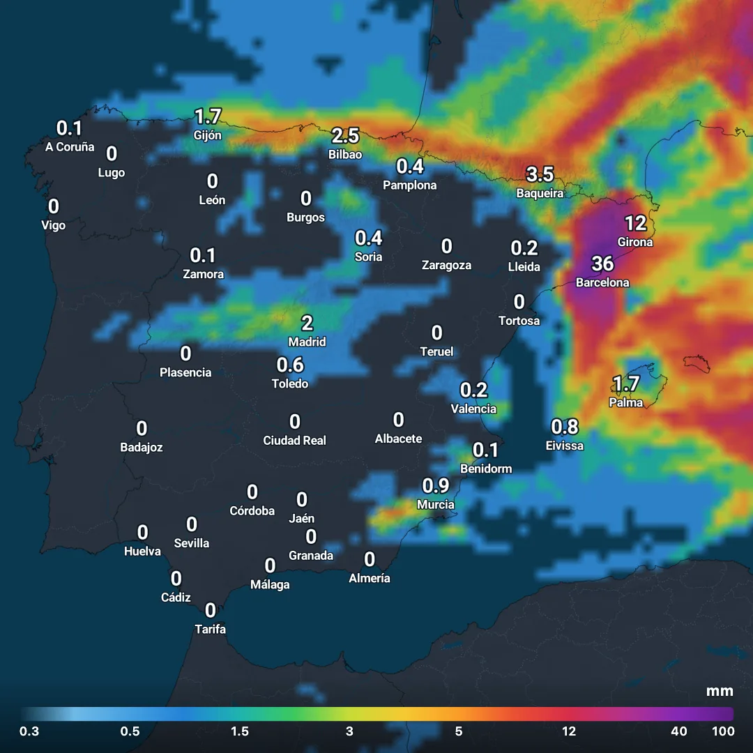
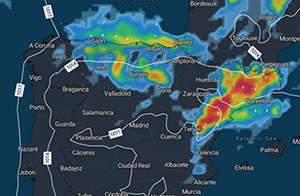
ICON-EU forecast from 3 October 2026: very high rainfall totals around Barcelona and Girona on Sunday, with unsettled weather lasting until Wednesday.
Text size
Line spacing
The unsettled weather over Spain is going into extra time. According to the latest ICON-EU forecast from Saturday morning, 3 October, the country stays under the influence of humid and unstable air at least until Wednesday. The situation becomes critical again in the northeast on Sunday: around Barcelona and Girona there is a risk of very heavy and locally exceptionally high rainfall.
The past few days have already shown how explosive the weather in the Mediterranean can be. Even at the end of the weekend there is no lasting calm in sight. On the contrary: while the focus of the rain keeps shifting over the coming days, showers and thunderstorms remain an issue in many parts of Spain.
The current ICON-EU calculations show a situation in which individual regions can receive enormous amounts of rain, while only a few hundred kilometres away it stays largely dry for a time.
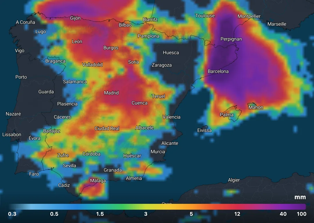
The ICON-EU forecast calculates around 129 mm of rain within the day for the Barcelona area and about 57 mm for Girona. These are model values for individual grid points and explicitly not guaranteed measurements. Locally, the actual amounts can differ considerably.
The signal is striking nonetheless: along the Catalan coast and in the hinterland in particular, there is again the potential for very heavy and possibly longer-lasting rainfall.
The current official warnings also support the assessment of a dangerous situation. For Sunday there are orange warnings for heavy rain in parts of the litoral and prelitoral of Barcelona and in areas of the province of Girona.
After the heavy rain of recent days, particular caution is advisable. In parts of southern Catalonia, rainfall totals of more than 200 l/m² have already been recorded during the current spell of severe weather.
Small rivers, streams, underpasses and low-lying roads in particular can become problematic within a short time during intense rainfall. Anyone in Barcelona, Girona or on the Costa Brava on Sunday should therefore follow the current warnings and the development on radar and NowCast closely.
ICON-EU calculates around 15 mm for Gijón, 13 mm for Madrid, 11 mm for León and just under 10 mm for Bilbao, among others. Rain also occurs in parts of Castile and León, Castile-La Mancha, Extremadura and Andalusia.
In the south the amounts are smaller in many places. Around 4 mm is calculated for Málaga, for example, while Seville, Córdoba, Granada and Almería could receive considerably less according to the current run.
Overall, Sunday therefore remains a decidedly changeable autumn day, but with very large regional differences.
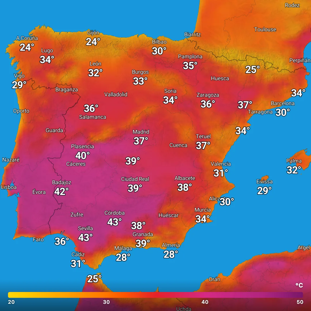
While the north and parts of the interior often reach only 18 to 24°C on Sunday, it stays decidedly warm in the south. ICON-EU expects, for example:
30°C in Seville, 28°C in Córdoba, 27°C in Almería and Murcia and 26°C in Granada, Cádiz and Benidorm. Málaga is likely to reach around 24°C.
On the Mediterranean coast, around 27°C is expected in Valencia, Palma and Eivissa.
According to the current ICON forecast, the intensity in the northeastern Mediterranean decreases at first. At the same time, a broad area of showers and rain develops again over central and western Spain.
For Madrid the model calculates about 18 mm, for Plasencia 11 mm and for Badajoz around 9 mm. Parts of Castile-La Mancha and Andalusia also see further rain.
On the southern Mediterranean coast, by contrast, things look comparatively calm. Málaga could still receive about 3 mm, while Almería and Murcia stay largely dry according to this model run.
Temperatures rise again somewhat in the north and northeast for a time. Barcelona and Girona could reach around 25°C, Zaragoza and Lleida 27°C and Murcia even 28°C.
On Tuesday, ICON-EU again shows numerous areas of rain over Spain. A band from the southwest across central Spain into parts of the north remains particularly striking.
Around 13 mm is simulated for Madrid, about 11 mm for Plasencia, around 9 mm for León and just under 9 mm for Ciudad Real. There is further rain in the north as well.
In the southeastern Mediterranean, on the other hand, the situation stays comparatively calm. Benidorm, Murcia and Eivissa could remain almost dry.
In terms of temperature Spain remains divided: according to the current run, Seville reaches about 29°C again, Murcia 28°C and Córdoba 27°C. In the north, by contrast, highs are often only between 17 and 24°C.
ICON-EU shows further rain especially over central Spain, parts of Andalusia and in the north. Madrid comes to just under 8 mm in the model, Toledo to a good 8 mm, Ciudad Real to around 6 mm and Córdoba to a good 5 mm.
There is further rain in the north as well. Around 17 mm is simulated for Gijón, for example.
At the same time, temperatures fall in many places. This is particularly clear in the north: according to the current run, Bilbao reaches only about 18°C, A Coruña 17°C and Burgos 16°C.
In the south it stays milder. Seville, Huelva and Málaga reach about 26°C, Murcia and Valencia around 27°C.
For Tuesday, ICON calculates rain mainly on the western and central islands. Just under 10 mm is shown locally for San Sebastián de La Gomera, around 6 mm for Valverde on El Hierro and about 3 to 5 mm for parts of Gran Canaria.
On Wednesday, some rain remains possible especially on La Gomera and Tenerife. La Palma could receive a few millimetres as well. Fuerteventura and Lanzarote, by contrast, stay largely dry according to the current model run.
AEMET also currently assumes that the unstable situation can last at least until Wednesday. At the start of the new week the situation in the Mediterranean should gradually ease, while showers and thunderstorms can continue for longer in the interior.
For holidaymakers, however, this explicitly does not mean four days of continuous rain across the whole of Spain. Many regions experience longer dry spells between the areas of rain, and pleasant phases can well establish themselves on parts of the southern and southeastern coasts in particular.
The decisive point is the high regional variability: where heavy showers or thunderstorms develop, a lot of rain can fall within a short time. Only a few kilometres away it can stay almost dry at the same time.
Because the location and intensity of convective heavy rainfall can still change at short notice, current radar and NowCast data are far more meaningful here than a model forecast that is several days old.
meteo365.es will continue to monitor the situation and will update the picture for Catalonia in particular.
The past few days have already shown how explosive the weather in the Mediterranean can be. Even at the end of the weekend there is no lasting calm in sight. On the contrary: while the focus of the rain keeps shifting over the coming days, showers and thunderstorms remain an issue in many parts of Spain.
The current ICON-EU calculations show a situation in which individual regions can receive enormous amounts of rain, while only a few hundred kilometres away it stays largely dry for a time.
Sunday: Barcelona and Girona particularly in focus
On Sunday, 4 October, Catalonia again deserves particular attention.The ICON-EU forecast calculates around 129 mm of rain within the day for the Barcelona area and about 57 mm for Girona. These are model values for individual grid points and explicitly not guaranteed measurements. Locally, the actual amounts can differ considerably.
The signal is striking nonetheless: along the Catalan coast and in the hinterland in particular, there is again the potential for very heavy and possibly longer-lasting rainfall.
The current official warnings also support the assessment of a dangerous situation. For Sunday there are orange warnings for heavy rain in parts of the litoral and prelitoral of Barcelona and in areas of the province of Girona.
After the heavy rain of recent days, particular caution is advisable. In parts of southern Catalonia, rainfall totals of more than 200 l/m² have already been recorded during the current spell of severe weather.
Small rivers, streams, underpasses and low-lying roads in particular can become problematic within a short time during intense rainfall. Anyone in Barcelona, Girona or on the Costa Brava on Sunday should therefore follow the current warnings and the development on radar and NowCast closely.
Central Spain gets plenty of rain as well
Catalonia is not the only region with rain on Sunday, however.ICON-EU calculates around 15 mm for Gijón, 13 mm for Madrid, 11 mm for León and just under 10 mm for Bilbao, among others. Rain also occurs in parts of Castile and León, Castile-La Mancha, Extremadura and Andalusia.
In the south the amounts are smaller in many places. Around 4 mm is calculated for Málaga, for example, while Seville, Córdoba, Granada and Almería could receive considerably less according to the current run.
Overall, Sunday therefore remains a decidedly changeable autumn day, but with very large regional differences.
The south stays very warm for now
At the same time, the large temperature contrast within Spain is remarkable.While the north and parts of the interior often reach only 18 to 24°C on Sunday, it stays decidedly warm in the south. ICON-EU expects, for example:
30°C in Seville, 28°C in Córdoba, 27°C in Almería and Murcia and 26°C in Granada, Cádiz and Benidorm. Málaga is likely to reach around 24°C.
On the Mediterranean coast, around 27°C is expected in Valencia, Palma and Eivissa.
Monday: the rain shifts further inland
On Monday the distribution of the rain changes noticeably.According to the current ICON forecast, the intensity in the northeastern Mediterranean decreases at first. At the same time, a broad area of showers and rain develops again over central and western Spain.
For Madrid the model calculates about 18 mm, for Plasencia 11 mm and for Badajoz around 9 mm. Parts of Castile-La Mancha and Andalusia also see further rain.
On the southern Mediterranean coast, by contrast, things look comparatively calm. Málaga could still receive about 3 mm, while Almería and Murcia stay largely dry according to this model run.
Temperatures rise again somewhat in the north and northeast for a time. Barcelona and Girona could reach around 25°C, Zaragoza and Lleida 27°C and Murcia even 28°C.
Tuesday: no stable calm yet
Anyone hoping for a quick return to lastingly dry weather will have to be patient.On Tuesday, ICON-EU again shows numerous areas of rain over Spain. A band from the southwest across central Spain into parts of the north remains particularly striking.
Around 13 mm is simulated for Madrid, about 11 mm for Plasencia, around 9 mm for León and just under 9 mm for Ciudad Real. There is further rain in the north as well.
In the southeastern Mediterranean, on the other hand, the situation stays comparatively calm. Benidorm, Murcia and Eivissa could remain almost dry.
In terms of temperature Spain remains divided: according to the current run, Seville reaches about 29°C again, Murcia 28°C and Córdoba 27°C. In the north, by contrast, highs are often only between 17 and 24°C.
Wednesday stays unsettled
On Wednesday, 7 October, the unstable phase is not yet completely over either, as things stand.ICON-EU shows further rain especially over central Spain, parts of Andalusia and in the north. Madrid comes to just under 8 mm in the model, Toledo to a good 8 mm, Ciudad Real to around 6 mm and Córdoba to a good 5 mm.
There is further rain in the north as well. Around 17 mm is simulated for Gijón, for example.
At the same time, temperatures fall in many places. This is particularly clear in the north: according to the current run, Bilbao reaches only about 18°C, A Coruña 17°C and Burgos 16°C.
In the south it stays milder. Seville, Huelva and Málaga reach about 26°C, Murcia and Valencia around 27°C.
The Canary Islands get their share too
The development on the Canary Islands is also interesting.For Tuesday, ICON calculates rain mainly on the western and central islands. Just under 10 mm is shown locally for San Sebastián de La Gomera, around 6 mm for Valverde on El Hierro and about 3 to 5 mm for parts of Gran Canaria.
On Wednesday, some rain remains possible especially on La Gomera and Tenerife. La Palma could receive a few millimetres as well. Fuerteventura and Lanzarote, by contrast, stay largely dry according to the current model run.
Only after that does a slow easing emerge
The new ICON run therefore broadly confirms the picture of a multi-day, decidedly changeable spell of weather.AEMET also currently assumes that the unstable situation can last at least until Wednesday. At the start of the new week the situation in the Mediterranean should gradually ease, while showers and thunderstorms can continue for longer in the interior.
For holidaymakers, however, this explicitly does not mean four days of continuous rain across the whole of Spain. Many regions experience longer dry spells between the areas of rain, and pleasant phases can well establish themselves on parts of the southern and southeastern coasts in particular.
The decisive point is the high regional variability: where heavy showers or thunderstorms develop, a lot of rain can fall within a short time. Only a few kilometres away it can stay almost dry at the same time.
Our particular focus: Catalonia on Sunday
For Sunday, developments in the provinces of Barcelona and Girona should be followed especially closely. The combination of very high modelled rainfall totals and existing official warnings makes the region the focal point of the current situation.Because the location and intensity of convective heavy rainfall can still change at short notice, current radar and NowCast data are far more meaningful here than a model forecast that is several days old.
meteo365.es will continue to monitor the situation and will update the picture for Catalonia in particular.